We accelerate
the return of farmers to the safe fields.
About the project
is an online service for collecting information about mined fields from a farmer, after which the request will be promptly processed by the Feodal team, directed to the MAC, and handed over to demining operators.
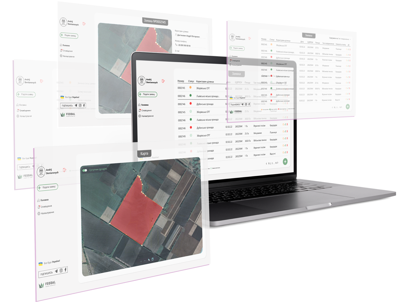
The project collaborates with the Interregional Center for Mine Action (MAC) of Ukraine and the Ukrainian Deminers Association, aiming to accelerate the lawful, high-quality, and safe humanitarian demining process in fields.
You do not need to know where the mines are to apply. Just having a suspicion of danger on your field is enough to submit an application and undergo a survey and demining (based on survey results).
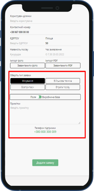
Each farmer can apply indicating mined fields or suspected landmine presence, as well as in case of discovering sabotaged or abandoned machinery, unexploded ordnance, or their fragments.
Collaboration
A simple and convenient way to return to a safe field.
Submit an application for demining through our platform.
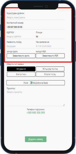
What do I need to have?
-
Phone number
(for logging into the personal account); - Last name, First name, Patronymic
- Company name
- The Unified State Register of Enterprises and Organizations of Ukraine (USREOU)
-
Email address
(for receiving the application letter)
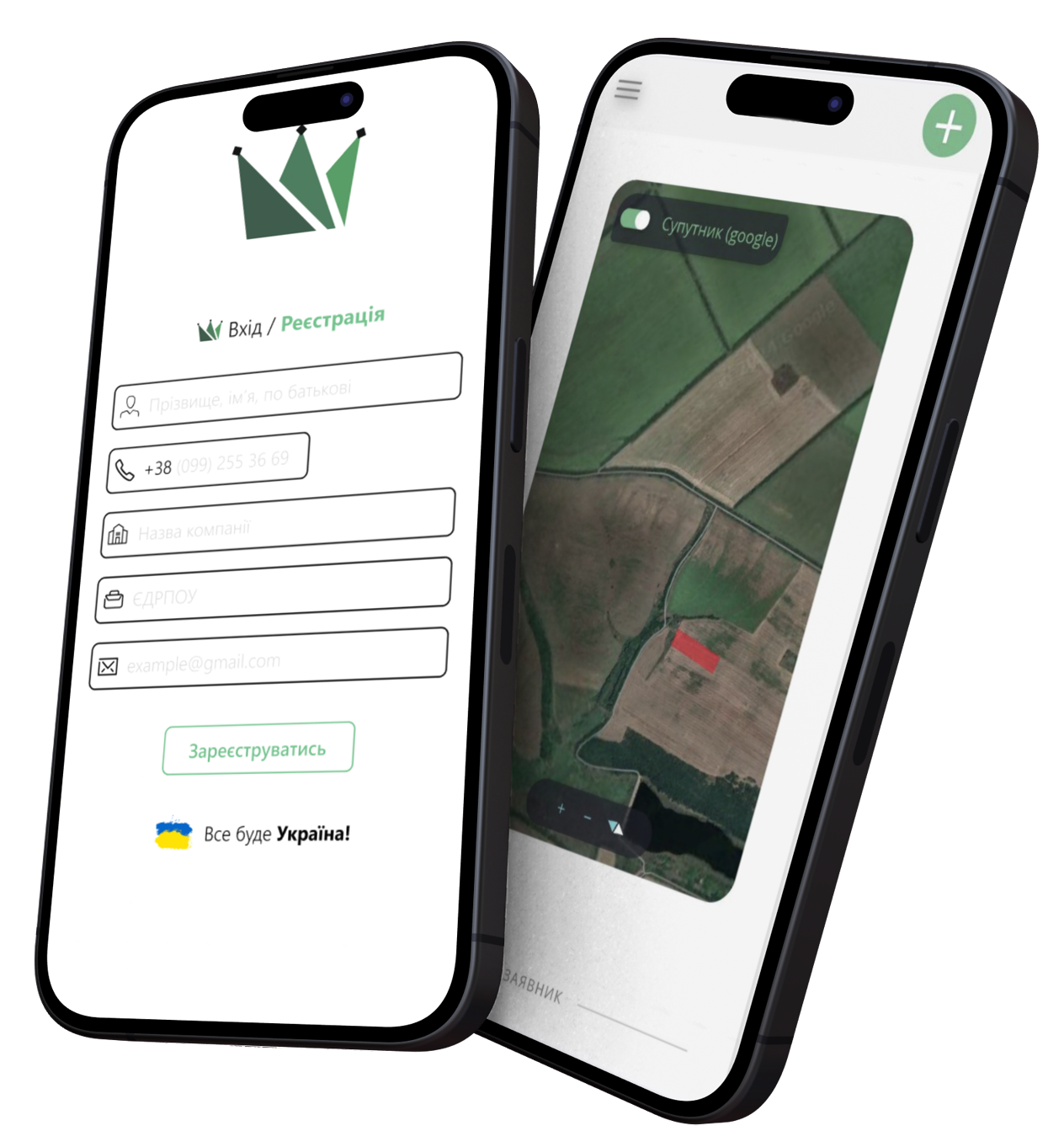
Let's proceed to the simple process of creating an application.
Application Submitted
How does the process of humanitarian demining take place?
1
The farmer submits an application on the website.
2
We verify the farmer's information and prepare letters and graphical materials for the farmer.
3
Automated transmission of application information to MAC and IMSMA
4
Obtaining permission for the operator for inspection.
5
Conducting Non-Technical Survey (NTS)
6
Technical survey.
Clearance (Demining).
7
Conducting thorough clearance and demining.
In case of evidence of danger is found during the
technical survey (TS), appropriate
measures are taken. If no evidence of danger is found,
the land will be considered likely safe.
Humanitarian demining
This is a set of measures, carried out by demining operators with the aim of eliminating dangers associated with explosive devices.
Humanitarian demining includes the following stages
Non-Technical Survey
NTS - Non-Technical Survey - is a procedure for surveying and assessing areas for the presence of explosive objects without the use of technical means. Surveying does not imply demining. During this procedure, an investigation is conducted without entering the field. Both direct and indirect evidence is identified, and beneficiaries are interviewed.
Assigning plot status
confirmed hazardous territory or potentially safe territory
Report Compilation
Verification by MAC
Automatic data submission to IMSMA
IMSMA - Information Management System for Mine Action
It is a digital platform or software designed for collecting and managing information related to mine action. The system is used by all mine action operators. Data from the military.feodal.online platform is processed by the manager and it is integrated into IMSMA. Thus, MAC and all mine action operators also have access to requests submitted through the Feodal service.
Report Compilation
Technical survey, report compilation
Clearance
Quality Check
Quality Check – the state inspection verifies the quality of demining using the same method as the demining itself.
Land transfer
Upon applying through the military platform, the farmer receives priority for free demining of the field conducted by a licensed company with experienced sappers.
Total
number of applications
Total number
of accepted applications
Total area
(in hectares)
IMPORTANCE
Humanitarian Demining
Humanitarian demining through our platform allows you to quickly obtain clean fields in the safest manner possible.
You will have official documents and properly demined fields, which are crucial for farmers to obtain permits, support, for accurate farm planning, etc.
Official
documents
We strongly advise against employing the services of unauthorized deminers, as it poses a potential threat to lives. Conducting an improper field survey can be excessively risky and may result in tragic consequences.
Q&A
Follow this link for the detailed instructions on how to submit an application.
Application submitted, now await a call from our team.
While you wait, we process your data, prepare graphical materials, and create an official application for obtaining permission for humanitarian demining.
Once we have your signed application (scanned copy), we are ready to submit it to the Center for Mine Action. All information, after verification, automatically goes to IMSMA – the global Information Management System in the field of Mine Action.
Next, we await the approval from the Ministry of Defense for the survey of the territories by the demining operator.
After obtaining permission, the demining operator adds the application to their demining plan. Now, a team of sappers works with you. When it's your turn, they come to the specified field according to the application and conduct a non-technical survey (NTS) of the declared area for the presence of explosive objects: without entering the field, they survey the area, find confirmations, evidence, direct/indirect, assign a status to your land plot. The sappers input relevant data, and you receive a report stating that NTS has been conducted. If the territory is identified as a confirmed hazardous area, then a technical survey (TS) is conducted.
After that, the sappers need time to form a plan to neutralize everything hazardous found during the TS.
And finally, when the plan is ready, the demining team arrives at the designated field(s) with all the necessary equipment and proceeds to neutralize explosive devices according to the developed plan. This is also a lengthy process as it can be mechanical / non-mechanical / manual, etc. As a result, you will receive not only cleared fields but also an official document confirming that your territory is safe.
It is a lengthy process. It can take 1-2 years, depending on the specific region and the nature of military actions in that area.
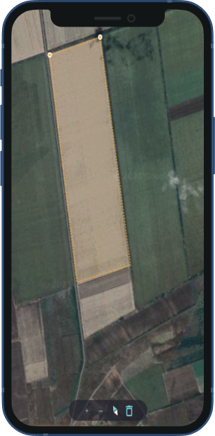
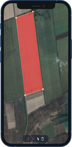
Yes, absolutely! No money is taken from the applicant for the field survey and demining. Therefore, when placing your application on our platform, please mark all your suspicious fields on the map. You have nothing to lose.
If the survey and demining in the specified areas are no longer relevant to you, simply inform us by phone, and we will update your request status to 'Not Applicable'.
If the application has already been signed, and changes occur after signing, you need to inform us so that we can update the application and send it back for your signature.
If you have just received a complited application with incorrect details such as an outdated field or wrong place name or district, you can make corrections yourself before printing the document.
If the application lacks a field or additional plots need inspection, you should create a new application. We will prepare coordinates and maps for the new plots and add them to the existing application to avoid creating multiple new applications.
You can take a photo of the signed application with your phone, but please do so in good lighting conditions to ensure its readability.
Yes, you can simply sign the application and send us a scanned copy.
I don't know what was happening in my fields, but the specified areas were under occupation / military actions were taking place / according to neighbors / etc.
We regret any inconvenience caused by the wait, but we would like to highlight that military.feodal.online is a service for collecting applications which we forward to demining operators. They prioritize the survey and demining process by regions/settlements.
Please take care of yourself, your employees, and do not expose yourself to danger by attempting to find and neutralize hazards independently. Please be patient!
If you are a private entrepreneur, enter as many digits as fit in the field.
The receipt of SMS with the code is not within our control. It depends on the mobile operator's service. If they are experiencing communication issues and you are not receiving SMS for an extended period, please wait until the stable connection is restored to avoid receiving multiple SMS with different codes.
If you have attempted to receive the code several times and still face issues, wait for the last SMS with the code and log into the system using the latest code.
You can initially:
- check if the phone number you entered is correct;
- clear the browser cache;
- try accessing from another computer.
However, if you still cannot access the system, please contact us by phone, and we will address this issue individually.
Check if you are entering the correct phone number. If the number is correct but you still receive notifications that the code is not valid, please contact us by phone, and we will address this issue individually.
Most likely, you have not filled in all the fields or have not outlined the polygon. Please check if you have followed all the steps correctly, as detailed in the instructions here.
Certainly! Your application will be stored in our system until permission is obtained to work in your region, or until you inform us that it is no longer relevant.
Outline on the map everything that is the part of your plot and describe it in the third section of the application.
When your fields undergo a non-technical survey by mine action operators and you obtain a document confirming the necessity for demining based on the survey results, you become eligible for exemption from lease payments.
Please seek help from those who can find your plots using cadastral numbers and convert them into KML or GeoJSON files. Then upload them to your application, and we will be able to process such data.
KML (Keyhole Markup Language) and GeoJSON (Geographic JavaScript Object Notation) are formats used for exchanging geographic information, representing geographical objects such as points, lines, polygons, and other geographic elements.
You can find them in open sources like OpenStreetMap or Data.gov, or create them yourself using relevant software, such as Google Earth.
Not all the farmers want to wait for their turn and seek quicker solutions to address the issue. In the black market, there are plenty of 'companies' of illegal sappers offering demining services. However, it's worth noting that, firstly, these services for farmers will be paid compared to the free service through a military application.
Secondly, and most importantly, such "rescuers" do not provide any guarantees.
Unfortunately, there have been several tragic instances of demining fields by 'black' sappers in Ukraine.
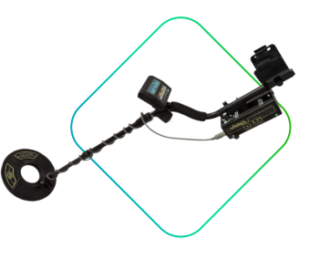
In addition, please, refrain from conducting independent field surveys using metal detectors or devising personal demining methods. Improvised techniques may inadvertently bury explosive items without detonating them, posing a deadly threat in subsequent seasons. Occupiers frequently leave plastic mines undetectable by metal detectors. Moreover, metal detectors have considerable margin for error. Sappers do not depend solely on metal detectors for demining, using them only as supplementary tool.